A multidisciplinary team of remote sensing scientists has outlined a new dual-pathway framework designed to make satellite measurements of coastal sea surface salinity more accurate and operationally useful. The proposal, presented in a research perspective and highlighted today in a press release from Fayetteville, Georgia, addresses long standing obstacles to deriving high quality salinity maps near shore from L-band microwave radiometers.
What the framework changes
Satellite L-band radiometry, which senses natural microwave emission from the ocean near 1.4 gigahertz, already provides a direct physical pathway to estimate sea surface salinity in the open ocean. However, the method struggles closer to land where bright land signals, shoreline contamination, sharp salinity gradients, and small scale ocean dynamics degrade retrievals. The dual-pathway approach brings together two complementary technical tracks to tackle these problems.
The first pathway emphasizes measurement cleaning. It targets improvements in interferometric radiometry processing and calibration to reduce land contamination, side lobe leakage, and radio frequency interference. Enhancements in instrument imaging, better treatment of instrument beam patterns, and advanced cleaning algorithms are intended to preserve L-band salinity signal even when measurements are taken near coastlines.
The second pathway focuses on strengthening forward physical models. That work seeks to deepen and refine the physical description of how sea surface conditions, such as waves, currents, surface roughness, temperature, and freshwater runoff, affect microwave emission. By embedding more realistic models of ocean surface physics and coastal processes in retrieval algorithms, the framework aims to prevent systematic errors caused by relying on open ocean assumptions in coastal environments.
Research basis and documentation
The dual-pathway concept is presented in a peer reviewed perspective published in July 2026 in the Journal of Remote Sensing. The article lays out a three phase roadmap with measurable priorities for instrument development, algorithm advances, and validation strategies that would move coastal salinity retrievals from research demonstrations toward operational products.
Today’s press notice, distributed from Fayetteville, Georgia, summarizes that perspective and highlights how combined advances in cleaner interferometric observations and improved forward modeling can together close the accuracy gap between open ocean and coastal salinity products.
Why coastal salinity matters
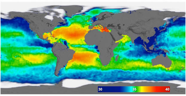
Sea surface salinity is a key climate and oceanographic variable. Variations in salinity reflect changes in the balance of evaporation, precipitation, river discharge, and ocean circulation. Near shore, salinity influences estuarine ecosystems, fisheries, harmful algal blooms, and the intrusion of seawater into freshwater sources. Higher fidelity coastal salinity maps could therefore benefit climate monitoring, coastal water management, and operational forecasting for marine safety and resource planning.
Existing spaceborne salinity missions and datasets have been transformational for open ocean research, but coastal regions remain a blind spot. The research team positions the dual-pathway framework as a practical roadmap to extend the strengths of L-band radiometry into those critically important coastal zones.
Practical steps and validation
The proposed roadmap recommends coordinated steps for the research and observing community. These include targeted airborne and in situ campaigns that pair high fidelity radiometer measurements with ship and buoy salinity profiles near river plumes and estuaries, improved radiometer calibration approaches, and integration of active and passive microwave measurements to separate surface roughness and salinity effects.
Crucially, the authors stress independent validation using collocated in situ observations, regional process studies, and cross comparison with other satellite data streams. They argue that only systematic multi-platform validation will reveal residual biases and ensure the resulting coastal products are fit for science and management use.
Implications and timeline
The research paper outlines a phased timeline intended to guide instrument designers, mission planners, and algorithm teams over the next several years. Short term priorities include algorithm demonstrations and targeted campaigns. Medium term goals emphasize upgrades to radiometer imaging and calibration to reduce leakage. Longer term work contemplates integrated mission concepts and operational coastal salinity services that could feed regional ocean models and decision support tools.
If implemented, the framework could enable monitoring of rapid freshwater events such as large river discharge, storm induced coastal mixing, and episodic freshwater intrusions, giving coastal managers and researchers a new remote sensing capability for events that today rely mainly on sparse in situ sampling and models.
What to watch next
Progress will move fastest where research groups, space agencies and instrument teams coordinate campaigns and share calibration best practices. Watch for announcements of airborne validation flights, focused coastal field experiments, or demonstrations that combine interferometric L-band imagers with dense in situ sampling. Those activities will be the earliest tests of whether the dual-pathway approach delivers the promised gains in accuracy and resolution.
For coastal communities and ocean scientists, the dual-pathway roadmap offers a clear research agenda. By attacking both measurement contamination and model fidelity together, the approach aims to close a long standing gap in satellite oceanography, bringing operationally useful salinity information closer to shore where it is most needed.